 |
| City Hall, 1 Junkins Avenue, Portsmouth, NH 03801 Tel: (603) 431 - 2000 |
|
 |
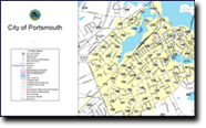
Maps of Portsmouth
DYNAMIC MAPPING TOOLS
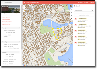 MapGeo permits users to view combinations of layers, search parcels by property owner, address, or parcel, and to perform tasks including measurements and map creation. Thematic overlays for zoning, polling and ward locations, elementary school districts, and solid waste and recycling routes maps. MapGeo permits users to view combinations of layers, search parcels by property owner, address, or parcel, and to perform tasks including measurements and map creation. Thematic overlays for zoning, polling and ward locations, elementary school districts, and solid waste and recycling routes maps.
Click here or on the image to enter MapGeo.
STATIC MAPS
The links below will take you to maps of Portsmouth that you can view and download as PDF files. They were produced using data from Portsmouth's geographic information system (GIS).
TAX MAPS (PDF)
CITY MAPS (PDF)
- Downtown Portsmouth(172 KB): This is especially useful if you're enjoying Portsmouth on foot. It shows the locations of parking lots, parks, and other points of interest.
- Bicycle Rack Locations A map of all the it bicycle rack locations in the downtown area.
- Wi-Fi Map of Downtown Portsmouth A map of the free outdoor Wi-Fi coverage and average throughput over Prescott Park and the City of Portsmouth, NH.
- Accessible Parking Map This map outlines all the designated parking for vehicles with drivers or passengers authorized to utilize spaces reserved for people with walking disabilities.
- Recycling Route Map This map shows you which day your trash and recycling is collected.
- Parks in Portsmouth This map includes all the Parks in Portsmouth.
- Dog Off-Leash Area This map includes all the dog off-leash areas in Portsmouth, including the on/off leash area on Pierce Island.
- Portable Street Map(2 MB):
This is a portable version of the Portsmouth Street Map. You can print it as a 10-page book on normal-size printer. It includes an index for looking up streets.
- Portsmouth Zoning Map:This zoning map shows the Zoning Districts within the City of Portsmouth. A complete definition of each zone, tables of uses and other descriptive information is contained in the City of Portsmouth Zoning Ordinance, which is also available in a digital format on this website. A paper copy of the Zoning Ordinance or Zoning Map can be obtained in the Portsmouth Planning Department.
- Portsmouth Street Map(845 KB): This large, indexed map will help you find your way around Portsmouth. It was designed to be printed on a 36"x48" piece of paper, so it's a little difficult to view on a computer screen, but it does show all the streets.
- Portsmouth Street Map 11x17(656 KB): This map is best printed on 11"x17" paper.
- Historic District Map(340 KB): This map may not accurately represent all areas of the Historic District. Please see the official zoning map located in the Planning Department at Portsmouth City Hall for the definitive representation.
- Printable Basemap(146 KB): This is a letter-sized map that you can print on an ordinary printer. It doesn't show the names of the streets, but it's handy if you want a map that you can draw on.
- Downtown Snow Removal Map(16 KB): This map covers snow removal operations after a storm, not to be confused with plowing operations during a storm. A citywide parking ban is in effect during storms that produce 2" or more of snow. Call 766-7669 (SNO-SNOW) for parking ban announcements or visit the City's Home page.
- Portsmouth Voting Wards(668 KB): If you have any doubts as to your ward, please contact the City Clerk's office at (603) 610-7245.
- Portsmouth Elementary School District Map(226 KB): This map will help you locate the elementary school in your district.
- Citywide Construction Projects: To view a map of all the Citywide Construction Projects please click here.
return
|
|
|
|
 Tax Maps - Parcel Map Library -
By downloading and opening the index pages an individual map page can be opened by clicking on the appropriate map number of interest. For example, if you are interested in seeing parcel 301-3. '301' is the tax map for where that parcel is located. Open the Pease Index map and click on the number 301, which will open a new pdf document which contains the Assessors Tax Map 301.
Tax Maps - Parcel Map Library -
By downloading and opening the index pages an individual map page can be opened by clicking on the appropriate map number of interest. For example, if you are interested in seeing parcel 301-3. '301' is the tax map for where that parcel is located. Open the Pease Index map and click on the number 301, which will open a new pdf document which contains the Assessors Tax Map 301.